
11 California Road Trip Stops Tourists Miss Because Nobody Tells Them

Most Route 66 road-trippers see exactly what the postcard rack sells: A diner, a fading sign, a quick photo, then back on the interstate.
That’s the whole trip for them.
Real history and roadside landmarks sit within a short detour of California’s busiest highways, and most drivers never learn they were there.
These are the California stops most tourists drive straight past without knowing what they missed.
1. Vasquez Rocks
Highway 14 runs right past Vasquez Rocks in Agua Dulce, about thirty miles north of Los Angeles, and most drivers never take the exit for the jagged red slabs beside the freeway.
The park is named for Tiburcio Vasquez, an outlaw who used the rocks to dodge California lawmen in 1874.
He hid well.
Since 1928, close to 200 productions have filmed here, including the “Star Trek” episodes that turned the tallest slab into a spot fans still call Kirk’s Rock.
The park charges nothing to walk in.
Fans hunting the exact spot from Star Trek’s 1967 episode “Arena” still climb the same red slab today.
2. Elmer’s Bottle Tree Ranch
Two acres of scrap-metal trees stand just off old Route 66 in Oro Grande, and most drivers blur past them at 55 miles an hour without a glance.
Elmer Long built the first tree in 2000 from bottles he and his father collected camping in the Mojave Desert since the 1950s.
He kept going.
More than 200 metal trees now hold thousands of bottles across the property, and Long’s family still leaves the gate open from sunrise to sunset.
Admission is free.
A wishing well out back takes donations, and the coins piled inside outnumber anything a visitor could count.
3. Amboy
A boomerang-shaped neon sign still glows over the ghost town of Amboy, on the National Trails Highway that used to carry Route 66 through the Mojave Desert.
Roy Crowl opened a gas station here in 1938, and it grew into a 24-hour motel, café, and garage busy enough to employ much of the town’s 700 residents.
Then Interstate 40 opened in 1972 and routed drivers around Amboy completely.
It happened almost overnight.
Preservationist Albert Okura bought the whole town in 2005 to keep it from disappearing, and restoration work still continues on Roy’s today.
The neon sign still flips on every night, even with the motel rooms empty.
4. Trona Pinnacles
A five-mile dirt road off Highway 178 near Ridgecrest leads out to rows of stone spires that look like nothing else in California.
The tufa towers formed underwater thousands of years ago, in a lake that dried up long before anyone paved a road nearby.
The site sits on land managed by the Bureau of Land Management (BLM), so admission and camping cost nothing at all.
Filmmakers have used the spires as a stand-in for alien worlds for decades, in science-fiction films and shows going back to the 1960s.
Skip the summer.
Temperatures top 110 degrees, so fall through spring is the window most visitors use.
5. Randsburg
Gold brought thousands of prospectors to Randsburg in the mid-1890s, and the ghost town they left behind still stands just off Highway 395 between Ridgecrest and Boron.
Within a year the boomtown held more than 2,000 residents and 300 buildings.
Then the gold thinned out.
Fewer than 50 people live in Randsburg today, and the weathered storefronts, a tiny jail, and rusted mining equipment along Butte Avenue never got torn down.
Neglect did the preserving.
Butte Avenue still looks the way it did when the miners left.
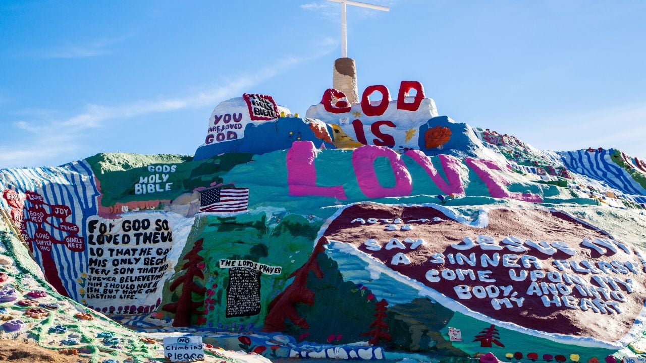
6. Salvation Mountain
A hill-sized message of hope rises out of the desert off Highway 111, past the small town of Niland near the Salton Sea.
Leonard Knight started building it in 1984, layering adobe, straw, and house paint by hand for the next three decades.
The mountain wasn’t his original plan.
The mountain sits at the edge of Slab City, an off-grid desert community built on the concrete slabs of an old Marine base.
Admission has always been free.
The mountain still runs through Halloween-orange, sunflower yellow, and ocean blue, hand-painted in every direction the eye can reach.
7. Bombay Beach
Bombay Beach sits 223 feet below sea level on the Salton Sea’s eastern shore, the lowest elevation of any community in the United States.
It’s also another stretch of Highway 111 most road trips skip entirely.
Vacationers swam, water-skied, and golfed here through the 1950s and 60s, back when Bombay Beach was a thriving resort town.
Then the sea’s rising salt and shrinking shoreline drove almost everyone out.
Artists moved in instead.
An annual art event called the Bombay Beach Biennale has filled the town with sculpture, a scrap-built opera house, and a drive-in theater since 2016.
8. Moaning Cavern
A cave that Native tribes considered sacred for centuries hides off Highway 4 near Vallecito, in the rolling hills of Gold Country.
Miners searched it for gold in 1851 and found none, but the moaning sounds echoing from its entrance had given the cave its name long before that.
The moans are gone now.
Digging out a wider public entrance quieted the sounds for good, though the name never changed.
A 100-foot spiral staircase, built in the early 1900s, still carries visitors down into the main chamber.
The room is tall enough to fit the Statue of Liberty.
Beyond it, an Expedition Tour route drops another 70 feet through passages nicknamed the Pancake Squeeze and the Birth Canal.
9. Fort Ross
Russian fur traders and Alaskan Alutiiq laborers built a fort on the Sonoma Coast in 1812, eleven miles north of Jenner on Highway 1.
They ran it as a farming and trading post for three decades before selling it off in 1841.
It’s the southernmost Russian settlement ever built in North America.
Reconstructed buildings, an Orthodox chapel, and a windmill still stand inside the redwood palisade walls.
Nobody’s allowed inside right now.
Fort Ross State Historic Park has been closed since the Woodside Fire damaged the grounds, and California State Parks hasn’t announced a reopening date.
10. Ferndale
Dairy money paid for an entire town of ornate Victorian homes at the end of Highway 211, a short detour off Highway 101 near Eureka.
Locals call them Butterfat Palaces, and the whole town became a state historical landmark after Ferndale’s founding in 1852.
The cows never saw it.
Highway 211 was meant to become the northern stretch of Highway 1, before engineers gave up on paving the Lost Coast and sent the route inland in 1984.
11. Fern Canyon
Fifty-foot walls covered floor to top in ferns line a narrow gorge at the end of Davison Road, an unpaved detour off Highway 101 a few miles north of Orick.
Steven Spielberg used the gorge as a filming location for “The Lost World: Jurassic Park.”
The canyon still looks prehistoric.
Between May 15 and September 15, visitors need a free day-use reservation to park at the trailhead.
Outside those months, no permit is required at all.
Some ferns still grow sideways out of the canyon walls instead of up from the ground.
10 Habits That Embarrass Californians the Second They Leave the State
A Californian steps off the curb mid-block in Nashville, no crosswalk anywhere in sight, and the driver in a pickup truck lays on the horn without slowing down.
They don’t even flinch because back in Long Beach, crossing the second the street looks clear is just what people do.
10 Habits That Embarrass Californians the Second They Leave the State
15 Things Californians Are Tired of Hearing From the Rest of America
A Californian mentions where they’re from at a wedding reception, and the questions start before the appetizers even arrive.
Is it always sunny? Have you ever felt an earthquake? Nobody waits for an answer before firing off the next one.
15 Things Californians Are Tired of Hearing From the Rest of America
